About the project:
Mapping the 1919 Chicago Riot is a collaborative project to visualize the 1919 riot combining original historical sources with modern geospatial technologies. We have compiled official reports and contemporary newspaper articles to map and detail incidents of deaths, injury and arson that occurred during the riots, as well as geo-locating original photographs taken during that time. Our goal is to make this information freely available to the general public and to provide scholars with spatial data to analyze the riot.
Disclaimer:
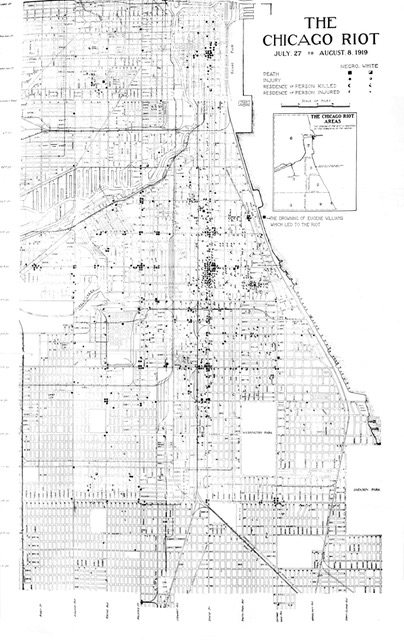
We cannot guarantee the accuracy of the data we have collected. The original sources (newspapers and reports) we rely upon are likely to have biases or omissions in terms of both which events are recorded and the details of those reports. We believe the data on deaths is most reliable, as these come primarily from the coroner’s report and the published report of the Chicago Commission on Race Relations (see the original map from that report below), both of which were based on extensive inquiries. The reports of injury and arson, by contrast, are from newspaper articles for which we have little idea of the coverage and reliability. Please note that the language in the articles and reports that we have digitized, transcribed and linked to the map often reflects the biases of reporters and officials.
Project team:
Project leader:
Archival research assistants:
Bokyoung Kim, Maggie Lu and Kian Yoo-Sharifi.
GIS Map makers:
Parmanand Sinha and Bibind Vasu.
Web Project Manager:
Kazutaka Takahashi
Web Developer:
Milson Munakami
Special thanks to:
Cosette Bruhns, Peter Cole, Lucia Geng, John Logan, Karen Seiber, Linda Zellmer and participants in the VUE Hackathon.